Building resilient communities
GM Urban Development and Delivery, Mark Fraser explains how good infrastructure can future proof our neighbourhoods against the effects of climate change
You don’t have to dig very far down into the ground in Mangere, South Auckland to understand that New Zealand has a legacy of development on floodplains.
Much of this development was done at a time where flooding risk was not nearly as well understood as it is today. Why then is the Government’s urban development agency, Kāinga Ora – Homes and Communities, continuing down this path, building thousands more homes on land that is prone to flooding?
The catastrophic flooding event of 27 January has shown the reality of brownfield urban redevelopment in low-lying areas of Mangere, Mt Roskill and Northcote is much more complex than a simple ‘to build or not to build’.
Climate change, a housing crisis and outdated, broken infrastructure buried in challenging land conditions like volcanic rock or boggy peat all present significant and often competing considerations for our development teams to respond to.
But perhaps the most important consideration is the duty of care we have to those communities who live there. We cannot turn our backs on them.
More extreme flooding events
Current climate change models indicate extreme flooding events will continue to hit these communities more intensely, more frequently, and more unpredictably in the years and decades to come. Every year these neighbourhoods sit on outdated infrastructure, they become more at risk.
As a responsible government agency tasked with supporting the growth of successful communities, we cannot allow nature to take its course and simply walk away; we must improve the resilience of our infrastructure, to not only meet the current needs, but also protect these communities in the future.
We are uniquely placed to achieve this because we do redevelopment at scale.
Throughout Mangere we have planned for 10,000 new homes to be delivered over 20 years - a mix of new homes for our public housing customers, as well as more affordable and market homes for those looking to buy.
The kind of density and scale we are planning allows us to justify the investment of new, future-proofed infrastructure at a neighbourhood scale, meaning we’re not just allowing for the infrastructure capacity of our Kāinga Ora homes, we’re looking at the entire suburb, delivering better flood-risk protection to benefit all residents in the community.
Investing in infrastructure
The scale of the upgrade we have planned across Auckland is ambitious and it’s backed by a $2b Government investment in infrastructure to deliver it. This funding, alongside commitments from Auckland Council and its organisations, will not only allow for the provision of up to 17,000 new homes across Auckland, but by planning infrastructure capacity on this scale, it will also unlock the potential for an additional 11,000 homes to be delivered on neighbouring privately owned land.
This means the residential construction sector can focus on building much-needed homes in these areas, as we’re making sure the infrastructure is there to support it, both now and in the future.
In January, we saw this neighbourhood-scale investment of new, well-designed infrastructure perform exceptionally in our more advanced developments in the Auckland suburbs of Hobsonville Point, Northcote, Roskill South, Ōwairaka and Tāmaki.
Doing the job
In Northcote, residents watched as the recently completed Greenslade Reserve filled up like a giant basin, completely submerging the high-performance sports field and surrounding park amenities with 12 million litres of water in just hours.
Before the upgrade of Greenslade Reserve in 2022 a less significant downpour would have flooded the neighbouring town centre and surrounding homes and streets. Yet in less than 15 hours after the flood, the water filling the reserve had drained away, the retail stores had reopened for business, and the fields were in use again.
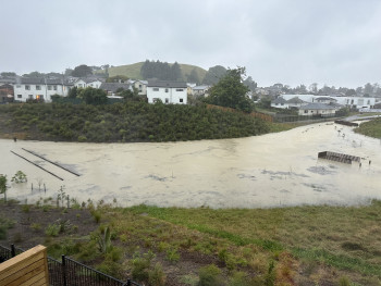
Floodwaters in Freeland Reserve
The daylighting of the nearby Awataha stream also ensured water that would have previously put pressure on stormwater pipes was redirected through the stream channels. This meant homes on nearby Tonar St (which previously experienced water flowing beneath their homes during heavy rainfall) reported no damage during the flooding event.
The newly completed Freeland Reserve now provides stormwater treatment and mitigation for about two-thirds of the entire Roskill South neighbourhood. The reserve is bolstered by three new floodwalls and Te Auaunga Awa (Oakley Creek) has been daylighted, allowing for a greater level of stormwater management.
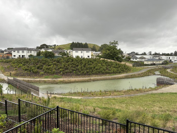
Freeland Reserve after the floodwaters had receeded
Freeland Reserve didn’t just do its job to hold back an extraordinary amount of stormwater. Additional design measures such as a spillway allowed water overflowing from the brim of the reserve to be channelled via an overland flow path onto roads, rather than backyards.
Across the motorway in Ōwairaka, the $32 million shovel-ready project to separate the old stormwater and wastewater network and increase capacity meant while rainwater could still be seen flowing down the streets on 27 January, the planned overland flow paths ensured it drained quickly, with very little damage in the previously flood-prone area and none to homes.
The Auckland Anniversary rainfall was well beyond most flood-modelling standards set to withstand current 1-in-100-year events. But this shouldn’t be a reason to stop what we are doing.
We now have a huge amount of up-to-date, real-world data from this event, meaning we’re going to get more accurate with our planning, and create better designed infrastructure than that which is based on modelling alone.
Building resilience
We also know that with infrastructure resilience comes other economic and societal benefits. By investing in these neighbourhood-wide upgrades we’re giving residents and local businesses the confidence to reinvest in their own assets, remain in their neighbourhoods and communities and thrive.
We are only just getting started in Mangere and, just like our other projects, we’ve undertaken extensive stormwater management plans, site investigations and surveys early in our development plans. Already we’ve installed several stormwater basins, new pipes and upgraded stormwater outfalls that successfully slowed down the flow of stormwater. There’s more work to come, with stormwater mitigation investment for the suburb in the coming years expected to exceed $220m.
While the infrastructure we’ve already built in Mangere is designed to withstand 1-in-100-year events, our ongoing work with Auckland Council and council-controlled organisations will now look at future planning to better respond to record-breaking rainfall events.
It is a collaborative effort, and involves a large investment, but we can begin to right the wrongs of New Zealand’s legacy development problems. It will now take thoughtful, evidence-based planning to design out the risk and increase the resilience of our communities.